![]()
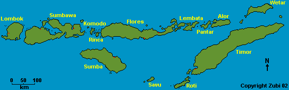
Nusa Tenggara is the Indonesian name for the over 500 islands east of Bali, running from Lombok in the west to Timor in the east. Nusa Tenggara stretches 1300 kilometer and lies just a few degrees south of the equator. The northern islands (Lombok, Sumbawa, Flores to Alor) are volcanic, the southern islands (Sumba, Savu, Roti and Timor) are uplifted coral limestone and sediment. There are over 40 volcanoes with half of them still active.
Please click here to get to a description of dive sites and diving conditions on the following areas of Indonesia: overview Indonesia - Lombok - Komodo and Rinca - Flores - Alor, Pantar and Lembata - Sulawesi - Bali
There quite a lot of dive operators in Lombok, but then only a few in the rest of Nusa Tenggara, namely in Laban Bajo and Maumere (Flores) and in Kupang (Timor). Most of the diving is done by liveaboard boats starting either from Sape (Sumbawa), Maumere (Flores) or Kalabahi (Alor).
We did a 2-week liveaboard trip from Flores to Alor, back again and on to the Komodo and Rinca islands.
Nusa Tenggara - a transition zone from Asian to Australian fauna and flora - print version
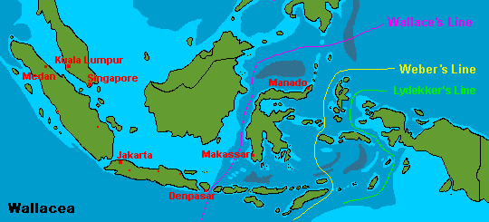
Wallacea encompasses the central islands of Indonesia east of Java, Bali, and Borneo, and west of the province of Papua on the island of New Guinea. It is dominated by the large island of Sulawesi and also includes the Moluccas, or Spice Islands, and the Lesser Sundas (Nusa Tenggara).
The Wallace Line (named after the naturalist Alfred Russel Wallace who explored the islands between 1854 and 1862) runs between Bali and Lombok, extending north through the Makassar Strait between Kalimantan (Borneo) and Sulawesi. The region west of the Wallace line is called Sundaland.
Another Naturalist, Weber was interested in how far Australian animals and plants spread into the Eurasian area. He noticed that he could draw a line between Sulawesi and Irian Jaya (= Indonesian part of Papua New Guinea) and between Timor and Australia. To the west, the fauna is more than 50 percent oriental, while to the east of the line, fauna is more than 50 percent Australian in origin.
Today biogeographers think of this area more like a zone of transition rather than a distinct line. This zone is called Wallacea and actually Nusa Tenggara lies right in the middle of it! Wallacea is specially interesting for naturalists and divers alike.
Wallacea is a so called biodiversity hotspot. The region supports incredibly high levels of endemism (= restricted to a particular geographic region and found nowhere else in the world). The marine life here is very rich. It is said that the photographer Rudie Kuiter catalogued in Maumere Bay (Flores) alone over 1200 species of fish including some new to science.
On land there are a great number of endemic species. Of the known Sulawesi (Celebes) fauna 62 percent of mammal, 27 percent of the bird 62 percent of reptile and 76 percent of amphibian species are endemic! For example there are marsupials (related to Australian kangaroos and possums) on the eastern islands, but they are not seen in the west of Sulawesi.
More information about Sir Alfred Russel Wallace / Information about the Wallace line
![]()
Information |
Dive sites around the Daymaniyat Islands, Kharabah, Fahal in Oman (maps, descriptions) - print version |
Photos |
Information |
Galapagos islands: center Galapagos, north Galapagos, southeast Galapagos, west Galapagos |
| Photos |
| Tauchplätze | Indonesien allgemein - Bali - Bali Nord - Bali Ost - Bali Süd - Bunaken - Bangka - Manado- Lembeh |
| Informations-Seiten | |
| Druckversion Karten | Indonesien (Strömungen und Wallace Linie) - Klima-Karte Indonesien - Bali Tauchplätze - Lembeh Tauchplätze - Bunaken und Manado Tauchplätze - Karte der Tauchplätze in den Galapagos - Druckversion |
| Druckversion Texte | Indonesien allgemein - Bali Nord - Bali Ost - Bali Süd - Bunaken - Bangka - Manado - Lembeh |
| Spezielle Themen | Grundsätze zur Berichterstattung über Tauchgebiete |
. Copyright Teresa Zubi (write to
me)