![]()
I have dived around the islands in Manado Bay several times, first in 1994, last time this year (2002). Usually I dive at the Bunaken Nation Marine Park, but this time I visited for the second time the outlying islands of Siau (didn't reach Sangihe though) with a liveaboard and went to the Lembeh strait and to the Bangka islands.
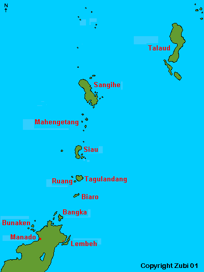
The Siau, Sangihe and Talaud islands lie to the northeast of Sulawesi (large map by Murex 190KB) and are dominated by the 1830m Karangetang volcano (list of Sangihe volcanoes Global Volcanism Program). This chain of around 40 steep and verdant volcanic islands connects Indonesia with the Philippines. The waters both east and west of these islands are deep with some oceanic trenches. The currents (the so called Indonesian Throughflow) bring plankton and nutrient rich water from the deep. As a result the marine life is very rich and varied. The best way to dive here is by liveaboard boat since there are no dive operators in the area.
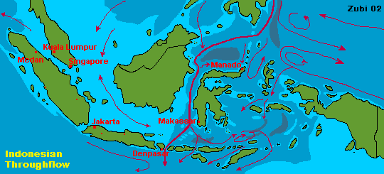
Map of the Indonesian Throughflow (current patterns in February print version - weather map Indonesia)
I made the trip twice, first on the liveaboard Arlena (2001) and then on the Serenade (2002). Our trip lasted 6 days and we visited Siau island, Mahengetang underwater volcano and Ruang island. Because of the weather we didn't go up to Sangihe both times. If you book a 2 week trip you can go further up, even to Talaud and there are also some dive operators in Manado that offer 2 or 3 day - trips to the Mahengetang underwater volcano north of Siau.
Please notice that which dives you can make may depend on the local weather. If waves are strong either from the east or west these places are avoided. On a liveaboard you can usually make 3 or more dives a day. Since a lot of dives are wall dives and considerable depths can be reached it is advisable to take a dive computer along on the trip. There were some places with quite a lot of current, sometimes changing in the middle of the dive and I encountered strong down currents several times on my trip. You are very far away from any help (look at the fact sheet for the nearest recompression chamber) so dive carefully!
Want to know more about how to assess accurately the rate of current? Click here.
![]()
![]()
Coming from Manado via Bangka, Biaro Island is the first island in the Sangihe chain. There is a steep cliff on the southern side, on the western side there is a village. On this side of the island a large flooded caldera open to the sea provides a sheltered area to anchor for the evening and a place to dive. There are several dive site around Biaro most of them on the eastern side (Zaccharias and Bomb rock, Lamango, Labyrinth, and Kalokoki)
Zaccharias and Bomb Rock: these dive sites are located in the northeast of the island. They are underwater pinnacles with sloping bottoms. Very nice corals, some table corals, dogtooth tuna, mackerels, snappers and bumphead parrotfish.
Ruang and Tagulandang island lie north of Biaro. Tagulandang island is the larger one but all the dive sites lie around Ruang. Ruang is dominated by a volcanic cone and there are two black lava flows that run from the crater at the summit into the sea, continuing underwater - amazing! We were anchoring just at the north side of the lava flow in a nice bay. I could see that there were some plants starting to grow on the lava, but not many. Click here for information on Ruang's volcano.
The old lava flow: There are stretches of black
sand and then coral blocks with a large variety of hard and soft corals and
black coral (the color is yellow or brown, the dead skeleton is black and
is used for jewelry).The black porous lava makes a perfect substrate for new
corals, sponges and other reef life and it seems that the ocean bed is able
to recover much more quickly from the volcanic eruptions than the land out
of the water! We also saw a large school of barracudas and 3 Napoleon wrasses!
The dive site is a slope with channels of sand, we reached depths of 20 to
35m. The visibility is 20 to 30 meter.
![]()
The new lava flow is a nice steep slope with
huge barrel sponges and coral blocks. We saw a lot of fusiliers, snappers,
butterflyfish, bannerfish and there was a spot with garden eels. On a second
dive we found pygmy seahorses in a Muricella gorgonian! Our dive was down
to 35m with variable currents.
![]()
There is one more dive site, Serenade's secret point,
which we didn't dive on. It is supposed to be a slope that drops off to a
wall with nice corals and large schools of fish.
![]()
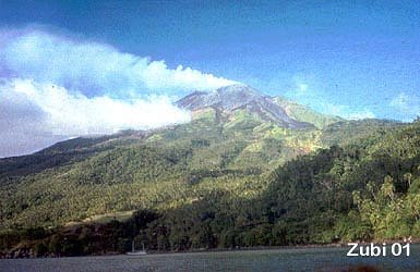
Karangetang Volcano in Siau, is also known as Api Siau volcano or Awoeh volcano and is 1827 m high. Karangetang is one of Indonesia's most active volcanoes, with more than 40 eruptions recorded since 1675! Click here for information about Karengetang (volcano information - directorate of volcanology, Indonesia). In the south there is the second, much smaller mountain Tamatu (500m). When arriving at Siau island we anchored at a small bay (at Batu Lehi) under the volcano. The peak of Mount Karangetang glowed red from the lava in the darkness while we were sitting in the hot pool nearby and small waves where lapping on the rocks. That's what real holidays are like!
Eddy Point: As soon as you jump in you realize, that you are diving on the shores of an active volcano. Everywhere is black porous lava rubble and sand. But the real surprise comes later, when you hear a series of sudden rumbelings. First I thought that someone had dropped a dynamite fishing bomb somewhere nearby, but then I realized, the noise was caused by the small eruptions of the volcano! Earlier from the boat I had seen long plumes of ash rise from the summit, sometimes larger clouds would rise and were dispersed by the wind. Underwater we now heard the workings of this volcano!
On the dive (37m but you could go deeper) we saw trevallies, large groups
of sweetlips and a sea snake (banded sea krait - Laticauda sp.) as well as
3 longnose hawkfish (Oxycirrhites t.) on some gorgonian fans. Strong current,
also some down current.
![]()
Batu Lehi is south of Eddy point along the steep
shore. It is a wall dive. There are masses of tube corals (Tubastraea sp.)
and I also found some colonial anemones (Amphianthus sp.). We saw some nice
large angelfishes and a Napoleon wrasse. We also did our night
dive here. We found lobsters, decorator crabs, a yellow cuttlefish
and a small bluespotted ray. When we surfaced the volcanoes top was glowing
red - welcome to the ring of fire - and the whole galaxy seemed to shine down
on us! We immediately swam over to relax in the volcanic hot springs on the
beach!
![]()
Close to Siau lie the 3 islands of Mahoro, Pahepa and Gunatin. There are some
dive sites on the east side such as Batu Jendela,
Paul's reef and Mula Kampung. We didn't
dive there, so I don't have more information about these dive sites.
![]()
Makalehi Island to the west of Siau is surrounded
by a fringing reef. You dive on the south side of the island at Needle
Point, a series of exposed pinnacles with strong currents. You can
see schools of jacks, fusiliers and bannerfish and a lot of needle corals
(Seriatopora hystrix) which gives this dive site its name.
![]()
The Banua Wuhu submarine volcano rises more than 400 m from the sea floor to form a shoal less than 5 m below sea level. Since it is located between Siau and Sangihe Islands, near Mahengetang Island ( 3° 08' N / 125° 26' E) it is commonly called Mahengetang underwater volcano. This volcano build several islands during the 19th and 20th centuries, one as high as 90m (in 1835) but they all disappeared again a few years later. In 1904 there were 5 craters, another new island that formed in 1919 had disappeared by 1935! Nowadays the volcano lies completely underwater.
I had visited this place in 1994. At that time we made a 2 day trip with ferry to Siau and continued by hired speedboat just to dive at the underwater volcano. The weather was very bad but we jumped in the same. I remembered a volcanic vent with hot sand and bubbles coming out of the ground everywhere and huge clams and sponges. And I remembered that my divesuit had stayed back in Manado (!) and I came back with a nice rash on my leg from fire corals! So I was really looking forward to visit this amazing place again and I wasn't disappointed! This time I came prepared - I had my 3 millimeter suit and my camera along!
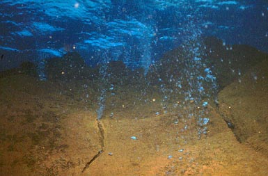
Mahengetang underwater volcano: As soon as you jump in the water you realize that you are diving on top of a volcano. There is a whiff of sulfur in the air and there is quite a bit of surge over the spiky top of the volcano.
We went to the top of the underwater volcano towards the end of our dive,
first we swam along the beautiful reef. The water was incredibly clear, I
estimate visibility of over 40m, because we clearly saw the reef structures
on the other side of the canyon far away. The reef seemed totaly unspoiled
- a valley with beautiful corals, lots of hard corals (cabbage corals etc.)
and barrel sponges (Xestospongia t.), just huge, over meter and a half high
on the slopes. Then the scenary changed, yellow sulfur deposits started to
cover everything like a thick coating of dust and the visibility worsened.
We were approaching the most extraordinary feature of this dive site - huge
boulders and rubble where hot gas and sulfur is released and floats as bubbles
to the surface. These bubbles form a nearly transparent curtain with fish
darting among them. A large mackerel stayed a long time just in front of us,
chasing bubbles. Later we saw a large school of mackerels but from far away.
![]()
Our second dive we made on Omsonee, also near
Mahengetang. This is a flat slope with a lot of hard corals. It is a nice
dive, we saw several large bumphead parrotfish, a lot of boxfish and butterfly
fish. There is also another dive site east of Mahengetang called
Nenung Pinnacles, but we didn't dive there.
![]()
These islands lie to the east and north of Mahengetang. There are dive sites at Nenung and Nitu, but we didn't dive there. No dive sites at Sanggeluhang island (also called Sanggaloang)
Kahakitang island ( 3° 10' 60N / 125° 31' 60E) has a beautiful, sheltered bay for spending the night and you can also make a night dive here. There are a lot of crabs, nudibranchs and other invertebrates. Shallow dive.
![]()
The Sangihe-Talaud islands (also called Sangir islands) spread down from Mindanao, south of the Philippines to the North Sulawesi peninsula with the Celebes Sea to the west and Maluku Sea to the east of the archipelago. They cover an area of 44.000 square kilometer of sea and 2.263 square kilometer of land. The district consists of 77 islands, of which 56 islands are inhabited. The largest islands of the Talaud group are Karakelang, Salibabu, Kabaruan, Karatung, Nanusa and Miangas. Most of the people live from agricultural products, such as coconut, vanilla, nutmeg and clove. The most northern island lies only 250km from Mindanao in the Philippines. The islands capital is Tahuna with the airport Naha 21 km away. There are flights to Manado and ferries to Bitung on Sulawesi.
A large volcano Gunung Awu ( 1,320 m) occupies the northern end of Sangihe Island. Gunung Awu (link to directorate of volcanology , Indonesia) is a very active volcano - the eruptions have caused more than 8,000 fatalities! The last eruption was in 1979. Another smaller volcano further south also regularly spews forth ash and lava.
These islands are inhabited by many rare and exotic birds and mammals. There are several parrots among them the Red-and-blue Lory (Eos histrio) and other birds such as the Talaud rail and bush-hen and the Sangihe scops owl that are very rare or nearly extinct. The Karakelang Hunting Reserve on Karakelang island is for hunting wild buffaloes and wild pigs, but it is also good for birding. Use the capital Beo as a base.
The remoteness of the region has helped to preserve the diversity of marine life. The water is crystal clear with visibility on average of 35 to 45 meter and sometimes more. The whole archipelago has breathtaking scenery including volcanoes above and below the water. The Sangihe and Talaud Islands are surrounded by deep, clear waters. I read reports of cetaceans such as sperm whales, pilot whales and a variety of species of dolphins as well as hammerheads and dog-tooth tuna. I only found information about the following diving.
Northeast ( 3° 45' N / 125° 45' E) of Sanghie island lies Inis island (weather information). The dive site has strong currents and schools of unicornfish, fusiliers and bannerfish.
The small Lipang island (weather information) is located nearly excately north ( 3° 55' N / 125° 22' E) of Sangihe. Napoleon wrasse and also hammerhead sharks were seen there.
The northwest side of Sangihe Island, north of Tahuna is a dive site called "lost city" - a village which has been swallowed by the sea in 1963 during an earthquake.
From Sangihe towards Mindanao in the Philippines there are several small islands such as Dalam, Kawalusu 4° 15' N / 125° 19' E , Kawio further north (4° 30' N / 125° 30' E), Hooiberg islands to the west ( 4° 7' N / 125° 7' E). These islands are are almost completely submerged and all touch the border of the Celebes basin. The dive sites here are completely unexplored and it seems that large schools of sharks and rays are common here.
![]()
![]()
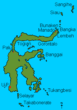
Map of Sulawesi: click on dive sites
|
Diving around
Manado Diving in Lembeh Strait Siau and Sangihe Diving in Central Sulawesi Diving in Southern Sulawesi Diving in Southeast Sulawesi |
![]()
Information |
Dive sites around the Daymaniyat Islands, Kharabah, Fahal in Oman (maps, descriptions) - print version |
Photos |
Information |
Galapagos islands: center Galapagos, north Galapagos, southeast Galapagos, west Galapagos |
| Photos |
| Tauchplätze | Indonesien allgemein - Bali - Bali Nord - Bali Ost - Bali Süd - Bunaken - Bangka - Manado- Lembeh |
| Informations-Seiten | |
| Druckversion Karten | Indonesien (Strömungen und Wallace Linie) - Klima-Karte Indonesien - Bali Tauchplätze - Lembeh Tauchplätze - Bunaken und Manado Tauchplätze - Karte der Tauchplätze in den Galapagos - Druckversion |
| Druckversion Texte | Indonesien allgemein - Bali Nord - Bali Ost - Bali Süd - Bunaken - Bangka - Manado - Lembeh |
| Spezielle Themen | Grundsätze zur Berichterstattung über Tauchgebiete |
. Copyright Teresa Zubi (write to
me)