Back to page about Sabah and Sarawak (Borneo) - Mabul / Sipadan maps
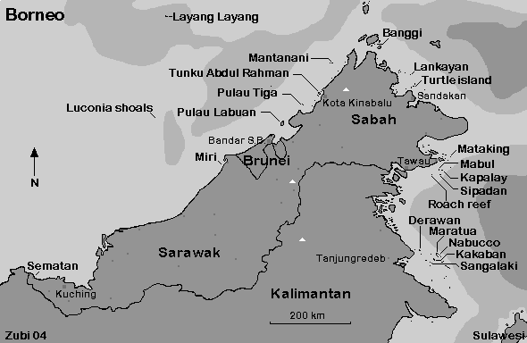
Map of the northern part of Borneo (Sabah, Sarawak, East-Kalimantan) with dive areas
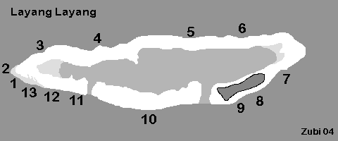
Map of Layang Layang dive sites: 1. Shark's Cave / 2. The Valley / 3. Wrasse Strip / 4. Crack Reef / 5. Navigator's Lane / 6. Gorgonian Forest / 7. Dogtooth Lair / 8. Wreck Point / 9. The Wall / 10. The Tunnel / 11. Snapper's Ledge / 12. D-Wall / 13. Channel
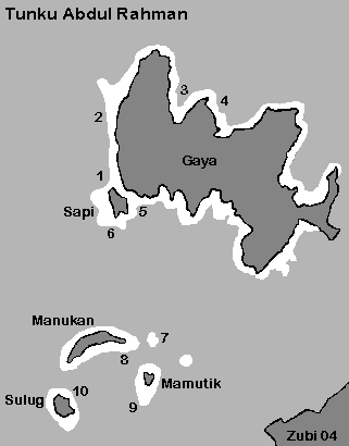
Map of Tunku Abdul Rahman National park with its dive sites: 1. Clement reef Seafans / 2. Agill Reef / 3. Police Bay (Bulijong Bay) / 4. Merangis Reef / 5. Sapi Jetty / 6. Ron Reef / 7. Mid Reef (black coral) / 8. Manukan Reef / 9. South Reef / 10. Sulug Reef

Dive sites around Pulau Tiga: 1. Coleman Shoal / 2. Larai Point / 3. West End / 4. Tiga's Trail / 5. House Reef / 6. UKM's Reef / 7. Asmarqa Point / 8. Phukat Point / 9. Midreef / 10. New Navigation / 11. Whip Garden / 12. Old Navigation / 13. Dunlop Corner